
Lake St Clair
Lake St. Clair
Carved by glaciers over millions of years, Lake St Clair lies at the southern end of Tasmania’s World Heritage-listed Cradle Mountain-Lake St Clair National Park. It is surrounded by dramatic mountain peaks and ancient forests that provide a setting for both short and multi-day walks. Lake St Clair is truly a sight to behold, with an atmosphere that has been described as “moody” and “ethereal”.
Lake St Clair can be accessed from the town of Derwent Bridge, which lies on the road linking Hobart with Strahan on Tasmania’s West Coast. It’s home to a scenic campground and a comfortable lodge, as well as the luxurious rooms of Pumphouse Point, which perches over the lake water.
Our Lake St Clair transfers offer easy access to the Cynthia Bay visitor’s centre, from where several walks depart. They are a convenient option for those who are exploring Tasmania without a rental car or are looking for a private transfer after hiking the legendary Overland Track.
Plunging 167 metres in some parts, Lake St Clair is Tasmania’s deepest lake and forms part of the iconic Cradle Mountain-Lake St Clair National Park. It lies at one end of the multi-day Overland Track that stretches from Cradle Mountain in the north and is home to several shorter walking trails that take in ancient pines and rugged mountain peaks.
Lake St Clair was created over intense periods of glaciation and moraines run along much of its length. The region has been home to Indigenous people for thousands of years and the Tasmanian Aboriginal people have a continuing relationship with what they refer to as leeawuleena (“sleeping water”). Aboriginal caves, rock shelters and stone tools have been discovered in the park and this history is explored along the Aboriginal Cultural Heritage Walk.
Native wildlife abounds, with Bennett’s wallabies and pademelons both regularly spotted along the lake shores, alongside wombats, echidnas and quolls. Platypus are also resident in the park, with aptly named Platypus Bay the best place to see them.
At Cynthia Bay on the lake’s southern shore is an award-winning visitor’s centre with exhibits detailing the natural and indigenous history of the park. From here, a passenger ferry connects north to Narcissus Bay, providing a scenic way to explore the lake, as well as providing transport to trekkers completing the Overland Track.
Lake St. Clair Walks
Lake St. Clair Circuit
Distance: 4.7 km | Time: 45 minutes to 1.5 hours | Start: Cynthia Bay
From Cynthia Bay, this leisurely circuit comprises three short trails that offer an introduction to the magnificent landscapes and vegetation within Cradle Mountain-Lake St Clair National Park. Learn about the indigenous people who lived on the lake shores for thousands of years along the Larmairremener tabelti walk, then hike to the confluence of the Cuvier and Hugel rivers on the Watersmeet Walk. From here, a short trail loops around to Platypus Bay where these unique marsupials are occasionally spotted.
Echo Point
Distance: 11 km | Time: 3-4 hours (one way) | Start: Cynthia Bay
A tiny walker’s hut marks Echo Point, which lies partway along Lake St. Clair’s western shore. This trail hugs the lake for much of its route, taking in ancient pine forests and offering magnificent views towards Mount Ida. It’s possible to hike one way and ride the ferry the other, with the boat journey along the lake taking just 20 minutes.
Mount Rufus
Distance: 19 km | Time: 7 hours | Start: Cynthia Bay
A highlight of this circuit walk is undoubtedly the views from Mount Rufus, which extend all the way to Mount Olympus, Mount Hugel and Frenchman’s Cap on a clear day. En route to the 1,416-metre-high summit, you’ll pass through tracts of eucalyptus, cool-temperate rainforest and sub-alpine terrain dominated by snow gums. Hiking in the early summer is particularly impressive when the scoparia is in bloom.
Overland Track
Distance: 65 km | Time: 6 days | Start: Ronny’s Creek (one way walk that completes at Lake St Clair)
Stretching from Cradle Mountain to Lake St. Clair, this iconic multi-day walk takes in some of Tasmania’s most stunning alpine wilderness. It is completed by most in six days but there are several detours that are worth an extra day or two. After exploring the park’s glacial lakes, temperate rainforests and wild moors, you’ll arrive on the shores of Lake St. Clair. From here, there is the option to continue hiking to Cynthia Bay or jump aboard the ferry for the leisurely journey to the Overland Track’s end.
In the middle of Tasmania, on the southern hemisphere's deepest lake, awaits a wilderness experience: Pumphouse Point. Walk deep into the fjord-like surrounds of Lake St Clair, explore the giant myrtle forests, tread softly on the moss-covered understory and forget the world you left behind. Credit Stu Gibson
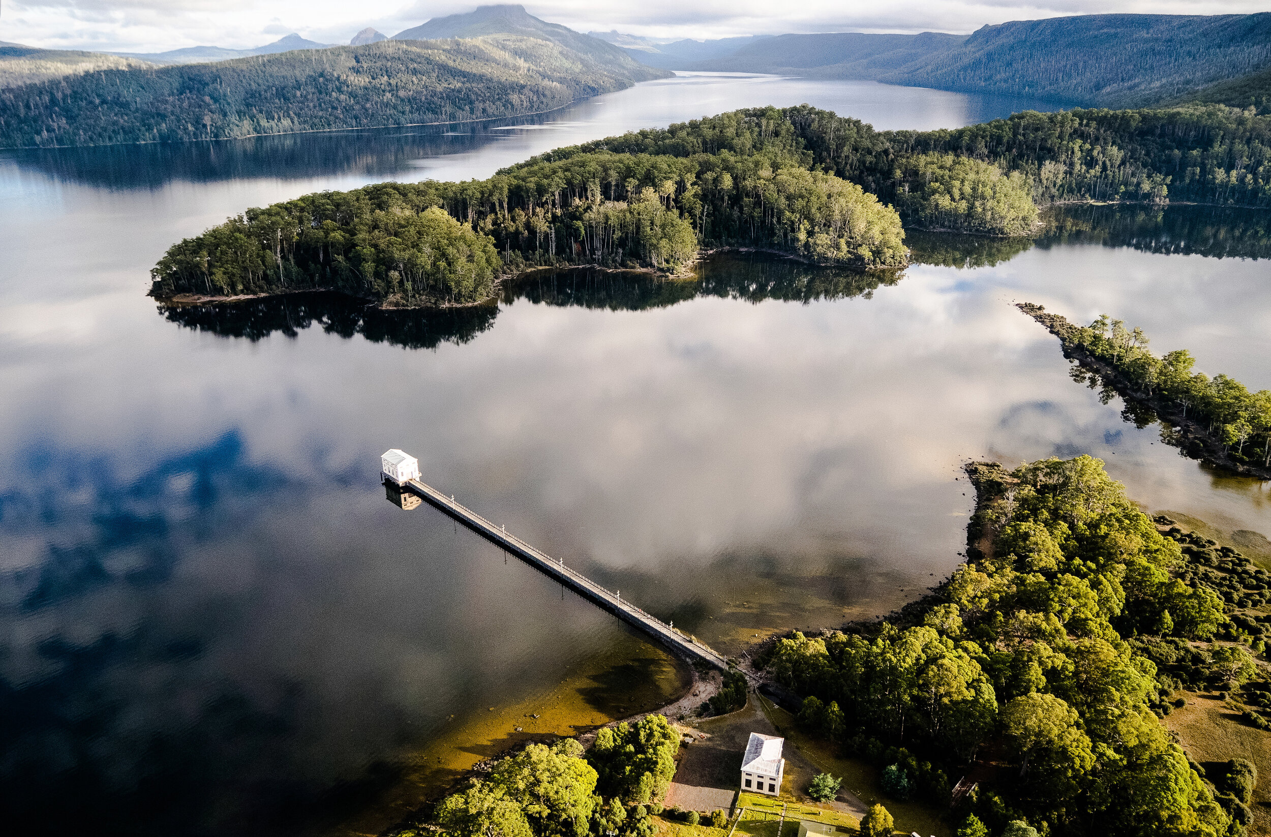
Narcissus Landing, Lake St Clair with Mt Olympus in b/g - Lake St Clair Walk. Lake St Clair is at the southern end of the world famous Cradle Mountain-Lake St Clair National Park and is part of the Tasmanian Wilderness World Heritage Area. Carved out by ice during several glaciations over the last two million years, this is the deepest lake in Australia and the headwaters of the River Derwent, upon which the capital city of Tasmania is located. Credit Tourism Tasmania & Joe Shemesh
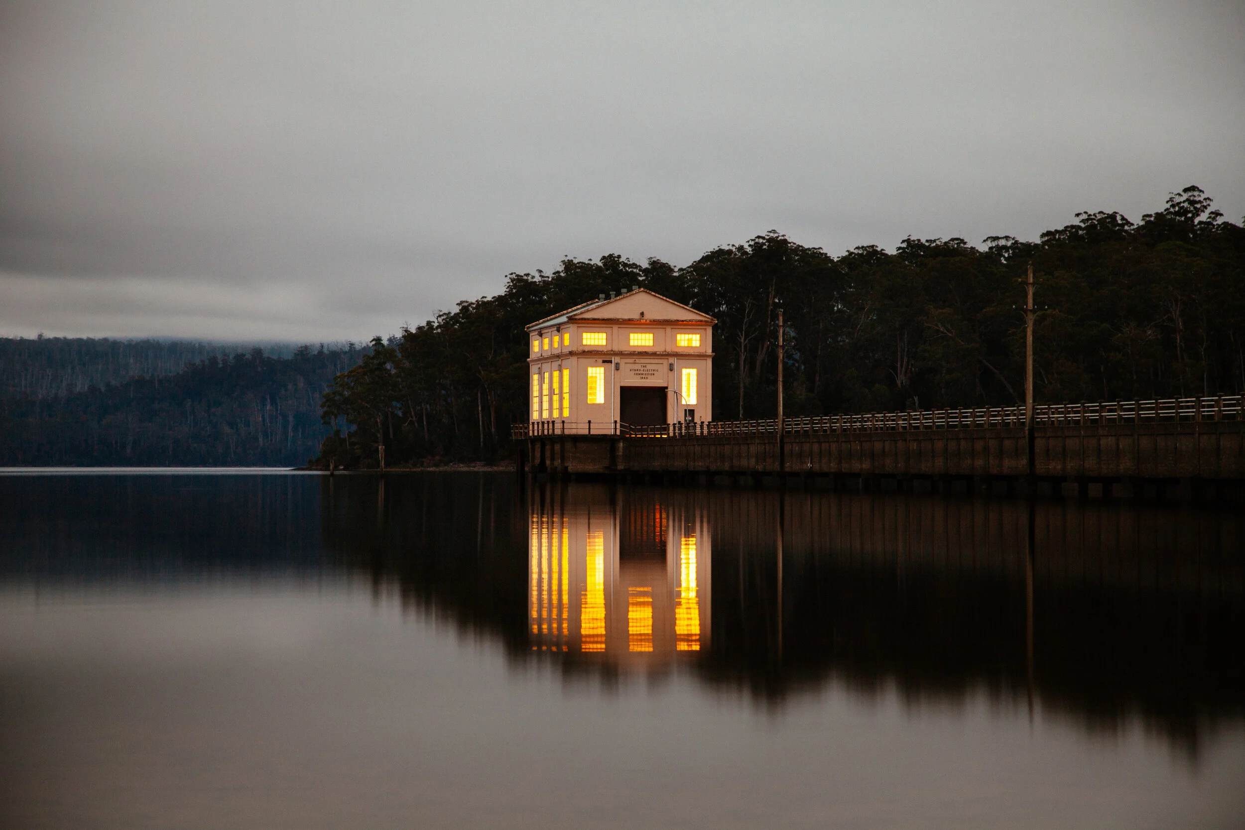

Mount Olympus and Lake St Clair. Credit Luke Tscharke
Pumphouse Point. Credit Stu Gibson